AG4000

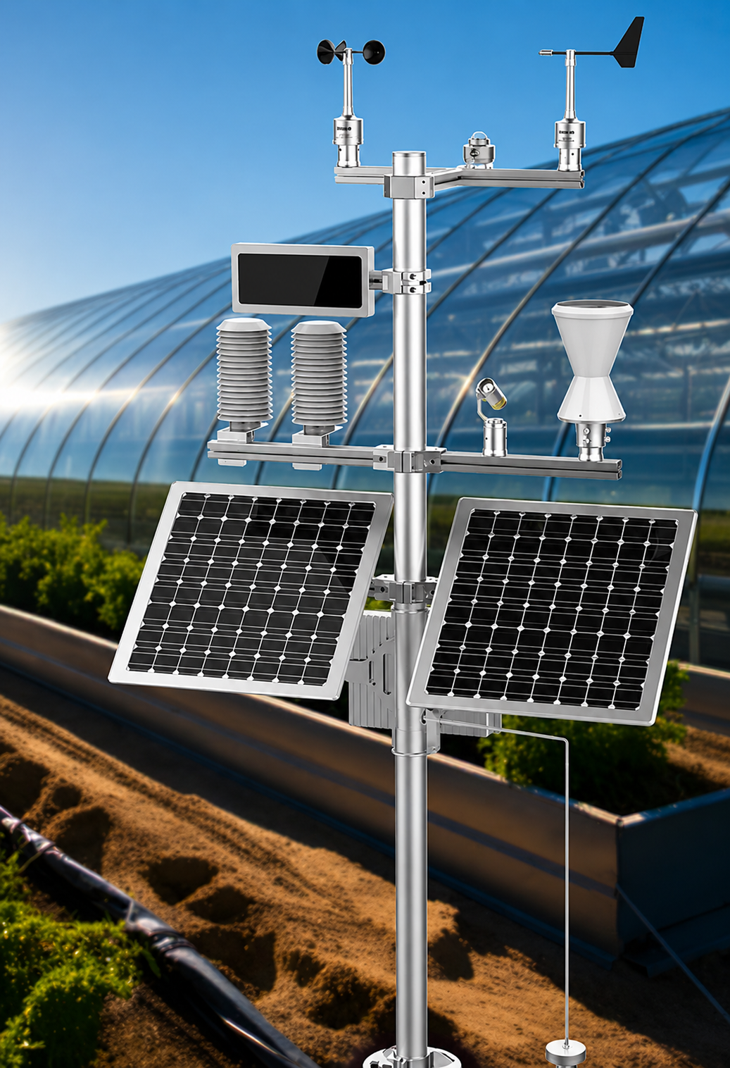
Agricultural Weather Station

A weather station specially designed for agricultural meteorological observation — temperature, humidity, air pressure, wind, rainfall, soil temperature, photosynthetically active radiation, carbon dioxide and infrared canopy temperature in a single solar-autonomous mast.

Soil + canopy temperaturePAR / CO₂15-day autonomy

The AG4000 is a weather station designed specifically for agricultural meteorological observation. It integrates temperature, humidity, air pressure, wind speed, wind direction, rainfall, soil temperature, photosynthetically active radiation, carbon dioxide and infrared canopy temperature with an optional real-time video terminal — the inputs needed to drive irrigation, frost, spray-window and growth-stage decisions from a single solar-autonomous unit.

The overall design adopts modular and solid-state concepts, reshaping the structure of traditional automatic weather stations and bringing more convenience to agricultural meteorological observations. A remote wireless link over WiFi, GPRS, 4G or LoRa connects the station to monitoring centres, and an optional wireless LED screen can publish current field conditions on site in real time.

Specification

Technical parameters

Temperature
Measuring range
−30°C ~ 70°C; −40°C ~ 60°C; −50°C ~ 50°C
Measuring accuracy
±0.1°C (23°C ±2°C); −40°C ~ 60°C full range ±0.2°C
Resolution
0.01°C / 0.02 °F
Humidity
Measuring range
0% ~ 100% RH
Measuring accuracy
±2.5%RH (10%~85%); other range ±5.0%RH (measurement environment 23°C ±2°C)
Resolution
0.01%RH
Air pressure
Measuring range
500 ~ 1100 hPa
Measuring accuracy
±0.10hPa (−10°C ~ 50°C); ±0.20hPa (−40°C ~ 50°C)
Resolution
0.01 hPa
Stability
≤ 0.2 hPa/year
Wind speed
Measuring range
0.5 ~ 65 m/s
Starting threshold
< 0.5 m/s
Transfer function
U = 0.1×R + 0.32 (U = wind speed [m/s], R = output pulse frequency [Hz])
Maximum allowable error
±0.5 m/s
Wind direction
Measuring range
0° ~ 360° (wind speed 0.5~65 m/s)
Starting threshold
< 0.5 m/s
Maximum allowable error
Better than ±2° (RS485); better than ±3° (7-bit Gray code); better than ±2° (0–5 V analog)
Resolution
±0.5° (RS485); ±3° (7-bit Gray code); ±1° (0–5 V analog)
Rainfall
Rain collecting area
200 cm² (φ159.60 ± 0.6 mm)
Resolution
0.1 mm
Rain intensity range
0 ~ 4 mm/min
Maximum allowable error
±0.4 mm (≤10 mm); ±4% (>10 mm)
Soil & canopy
Ground temperature range
−50°C ~ 150°C
Ground temperature accuracy
±0.1°C
Ground temperature resolution
0.01°C
Infrared canopy temperature
−40°C ~ 70°C
Infrared canopy accuracy
±0.2°C (−10°C ~ 65°C); ±0.5°C (−40°C ~ 70°C)
Infrared canopy resolution
0.02°C
Radiation & CO₂
Radiation spectral range
285 ~ 3000 nm
Radiation sensitivity (nominal)
115 µV / (W/m²)
CO₂ measuring range
0 ~ 2000 ppm
CO₂ measuring accuracy
±(30 ppm, +3% reading)
CO₂ resolution
1 ppm
System & interfaces
Main stream resolution and frame rate
50Hz: 25fps (2560×1920, 2048×1536, 1280×960)
Communication interface
RS232, RS485, USB Type-C virtual serial port, Ethernet, WiFi, BLE, 4G / LoRa
GNSS positioning and timing
BDS / GPS / GLONASS / GALILEO / QZSS / SBAS
Battery specifications
Lithium battery, capacity 30000 mAh × 3, 12 V
Solar panel power
45 W × 2
Internal storage capacity
1 million sets of data
External storage interface
SD card, USB external U disk
Storage function
Supports Micro SD/SDHC/SDXC card (128 GB) offline local storage; NAS (NFS, SMB/CIFS) supported
Operating time
Continuous rainy days ≥ 15 (with camera function turned on regularly)
IP level
IP65
Product dimensions
1280 × 850 × 2445 mm
More from this family

Pairs well with

See all agro models →